
Calling all volcano lovers! This multi-day hike in New Zealand is filled with dramatic landscapes to make your heart swoon – I know mine did. The Tongariro Northern Circuit (or Tongariro Circuit for short) is located in Tongariro National Park on the North Island of New Zealand. Due to the Maori history and cultural significance here as well as the unique showcase of geological features, this landscape shaped by three volcanoes became New Zealand’s first designated national park in 1894 and later a UNESCO World Heritage site.
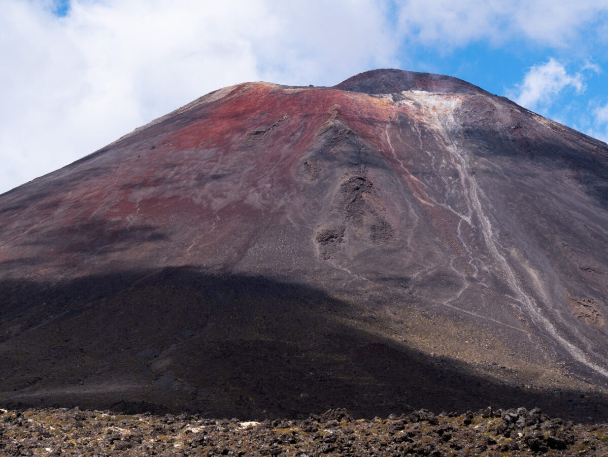
This Great Walk takes hikers through some of the most epic terrain in the whole national park: old lava fields, panoramic views of sacred volcanic peaks, steep and rocky terrain, geothermal steam vents, some pretty waterfalls – and of course the highlights, the Red Crater and the Blue and Emerald Lakes – which lie at the highest point on this track. While this wasn’t my first volcano experience, it was absolutely unbelievable and is in my opinion one of the must-do hikes for any hikers out there visiting New Zealand.
The Tongariro Northern Circuit was one of the seven first designated “Great Walks” in New Zealand when they opened this system in 1992. While most hikers opt to do the more popular Tongariro Alpine Crossing, which is a day hike that overlaps with the highlights on the Northern Circuit, the Circuit is the official Great Walk and is an amazing way to soak in some otherworldly volcanic landscapes for a few days.
In this post, I cover everything you will need to know in order to book and complete this amazing Great Walk. If you’re unsure about whether or not to do the Northern Circuit or the shorter Alpine Crossing, I also do a comparison of those as well to help you decide.
What is a Great Walk?
Great Walks are multi-day hikes (some can also be bike or paddle trips) designated by the government of New Zealand as places to see exceptional natural wonders or are tracks of great historical significance. The Great Walks system was first established in 1992 in an effort to preserve popular hiking trails by designating huts and campsites on the tracks and limiting the number of hikers to reduce environmental impact.
There are 10 Great Walks (though they are working on designating more in the future), and these are recognized as some of the most popular and scenic in all of New Zealand. The Great Walks are located all around the country in varying landscapes, and most of them lie within national parks. All of the tracks are designed to be done over multiple days, though there are some you can do in one day, or you can do parts of them in shorter chunks as day hikes.
Information About the Tongariro Northern Circuit
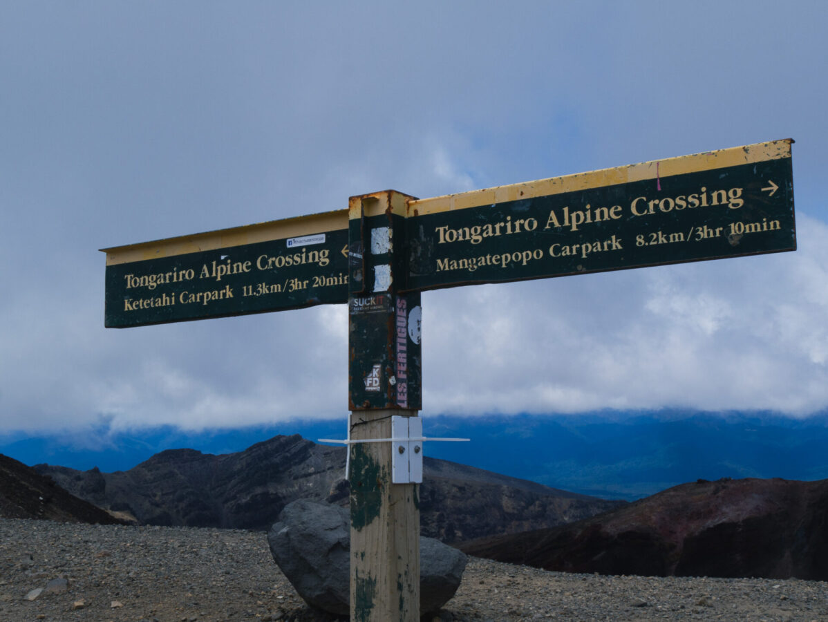
Location: This loop track is located within a volcanic field inside Tongariro National Park. It overlaps with and is a longer version of the more popular Tongariro Alpine Crossing day hike.
Distance: 44.9 km loop track, usually done over 2 to 4 days.
Elevation gain: Just over 2000 meters.
Weather: This area of New Zealand is located in the warmer climate of the North Island. However, the high altitude makes this park susceptible to snow during the winter months and unsafe storms with low visibility at any time of year. The track is mostly exposed and thus there is little shelter from the elements.
Tongariro Alpine Crossing vs Northern Circuit
Okay so what’s the difference between these two hikes? Which one is better? Since I’ve done the full Tongariro Northern Circuit, which overlaps with most of the Alpine Crossing, I have a pretty good idea of the pros and cons of each.
Tongariro Alpine Crossing
This day hike runs about 19 km and takes hikers 6-8 hours to complete. This hike covers the main highlights of the longer Northern Circuit, including the Red Crater, the crater lakes, geothermal vents, and the highest point on the trail. Since it is not a loop track, this hike requires drop off and return transport at either end of the track.
The Department of Conservation asks you to “book” your track, though at this point it is still free. This is so they can monitor how many people hike this track daily, as there are talks of limiting the number of hikers in the future.
Pros:
- Good option if you don’t have time to do the full Tongariro Northern Circuit
- Or if you don’t want to do a backpacking trip/don’t have the right gear
- Covers the main highlights
Cons:
- You have to pay for transport
- There is no car parking at some of the trailheads
- Even though this hike is shorter, don’t mistake it for being much easier. It still covers the hardest, steepest terrain and is also the number one rescue hike in New Zealand
Tongariro Northern Circuit
The longer track is stunning in its own right, but also comes with its own set of pros and cons.
Pros:
- Good option for people who want to fully immerse themselves in this incredible volcanic landscape for a few days
- While the section which overlaps with the Alpine Crossing is incredibly steep and challenging, most of the rest of the track is a bit more laidback
- No need to pay for transport – just your huts/campsites
Cons:
- The scenery on the track outside of the Alpine Crossing isn’t as dramatic
- Requires an advanced booking to secure spaces at the huts or campsites
How to Book the Tongariro Northern Circuit

All of the Great Walks have various campsites or huts that hikers can stay at throughout their time on the tracks, which generally need to be booked well in advance for the main summer season. Bookings for the year open up every April or May. Some of the tracks sell out very quickly, such as the Milford Track (which sold out in 4 hours in 2023) and the Routeburn Track. This Tongariro Circuit is also very popular, so it pays to book well in advance.
In addition to booking huts/campsites, some people choose to book transport for the Tongariro Circuit, though this isn’t necessary if you have a car because it’s a loop track.
See more about booking huts or campsites and transport below.
Northern Circuit Camping/Hut Options
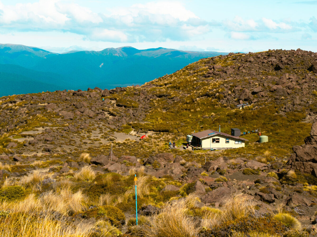
There are three huts with adjacent campsites located on this track: Mangatepopo, Oturere, and Waihohonu. Oturere Hut/campsite is at the midway point on the track, while the others straddle either end of the track.
Most people who hike this track do it clockwise over 2 or 3 days, but you can also take the slower route and do a full 4 days on the track. Doing the track clockwise offers the best views in my opinion. I did the track clockwise over 2 days and stayed at the Oturere campsite as this was close to the halfway point. While my days were long (8-9 hours), the main challenge on the whole track was the steep ascent up to the Red Crater; other than that section, the track wasn’t especially technical or challenging, so I didn’t mind the long days.
New Zealand Residents*:
Huts: $37/pp
Campsites: $16/pp
*If you’re international but have been living in New Zealand for at least 6 months, you can qualify for this rate with proof of utility bills or pay stubs.
International Visitors:
Huts: $56/pp
Campsites: $24/pp
Here you can find the link to book huts and campsites, as well as additional info from the Department of Conservation (DOC).
Which is Better: Huts or Campsites on the Tongariro Northern Circuit?
Unlike some of the other Great Walks, the huts and campsites on this track have shared spaces. The toilets, picnic tables, water, and sinks are shared and the locations are adjacent to each other; the only real difference is the sleeping areas. Either way, there are pros and cons to each option, outlined below:
Huts:
Pros: Beneficial if you want an indoor space to relax after hiking; good for getting out of inclement weather; come with pit toilets, gas stoves, water taps, sinks, fireplaces; you carry less stuff (no tent, no need for gas canister or stove)
Cons: You have to share a bunk room with other people, so not much privacy or quiet; expensive; less time out in nature
Campsites:
Pros: Beneficial if you have your own tent and hiking stove; you can have your own space; come with pit toilets, and a water tank; more time outside in nature; relatively inexpensive
Cons: Not a great choice if you don’t feel comfortable with the possibility of setting up or putting away tent in the rain, if you don’t want to get sand in your tent, if you don’t have a warm sleeping bag or appropriate sleeping layers if you’re hiking in the shoulder season, or if you don’t have all the camping and cooking gear required to be self-sufficient
Northern Circuit Transport
Since the Tongariro Circuit is a loop track, there is no need for transport if you have a car. Most of the hikers who need transport are doing the shorter Tongariro Alpine Crossing, which overlaps with this track but is point to point and thus requires a car or bus pickup. However, there is also transport available for those coming from out of town or who want to shorten the hike a little.
Self-Drive
The Tongariro Visitor Centre will give you a tag to put in your car so you can park it without penalty for the duration of your hike. The start of the track is walking distance from the parking lot in Whakapapa Village.
Transport Options
There are various transport options to and from the hike if you don’t have a car. The closest is from National Park (the main town which services Tongariro National Park). Main services can bring you either to Whakapapa Village, where the start and end of the track meet, or to the Mangatepopo Shelter, which cuts off 9.4 kms of hiking on day 1 if you do the hike clockwise. Other popular pick up and drop off locations are Lake Taupo and Turangi, or from outfitters near Whanganui National Park.
Essential Packing List & Tips for Hiking the Tongariro Northern Circuit
What to Pack for the Tongariro Circuit
This packing list is for hiking during the main Great Walks season (October-April).
- 40-60 Liter backpack
- 3 season sleeping bag
- sleeping bag liner (if camping in shoulder season and you don’t have a 4 season sleeping bag)
- 3 season sleeping pad (if camping)
- 3 season tent (if camping)
- backpacking stove, fuel canister and lighter (if camping)
- cutlery, cup, bowl, pot
- enough food and snacks to last for your trip (plus a little extra just in case), electrolytes
- headlamp
- cold weather clothing (down jacket, fleece or sweater, long sleeve layers, pants, beanie, gloves, neck gaiter, extra pants layer, etc.)
- warm weather clothing (quick drying t-shirt, quick drying shorts)
- wet weather clothing (waterproof jacket, water resistant and quick drying pants and/or waterproof pants)
- extra set of clothes to sleep in and camp shoes (sandals or crocs work well)
- toiletries
- sunscreen, hat, sunglasses
- first aid kit/medications
- water bottles or water bladder (at least 2 liter capacity) plus a water filter
- phone and portable phone charger
- offline GPS map (I use the maps.me app on my phone)
- hiking boots or trainers (waterproof and with good traction)
- optional: hiking poles, headphones, book or journal/pen, camera
Safety on the Tongariro Circuit
While many might consider the proximity to volcanoes a threat to them, for the most part, walking near these volcanoes is usually safe as they are monitored daily for activity.
More commonly dangerous than volcanic activity is hiking at the higher elevations during extreme weather or coming unprepared! This track has signposts marking the way, but during times of low visibility, these markers can be difficult to see. Further, much of the track at the high elevations are rocky, so there is not an easily identified trail to follow either. This combined with bad weather and hiker unpreparedness has caused numerous deaths on the Tongariro Alpine section of the track. The Tongariro Circuit is truly awe-inspiring and there is no need to fear if you come prepared on this hike! The most important thing to remember is to avoid hiking this track during bad weather and coming fully prepared with enough food and water and appropriate clothing to stay warm and dry. Below are some essential safety tips for this track.
- Have access to an offline GPS map! I use the maps.me app on my phone, which is free, but there are others that offer paid subscriptions such as Gaia or AllTrails. This is handy in case you find yourself accidentally off trail or simply want to know where you are on the track.
- Bring a GPS tracker. This will signal your location to a rescue team if activated, and could save your life, or someone else’s. Since I hiked this track alone, I decided to rent one from the visitor centre. I paid around $30 for a 3-day rental.
- Make sure to bring along a water filter as the provided water on the track is untreated.
- Since the majority of this track is entirely exposed, except for a small section of trees between the Oturere and Waihohonu Huts, there is no shelter from the elements. That means if it’s sunny, you’ll want loads of sunscreen and a hat, and if it’s raining, you’ll want good waterproof gear.
- Due to the high elevation on this track, sometimes the weather at the higher elevations can be different than weather elsewhere on the track. For this reason it’s important to come prepared with extra layers for keeping dry and warm, even if it looks sunny out!
- If for any reason you feel (or the ranger told you) that hiking over the Red Crater may be dangerous due to weather circumstances, you can always stay at one of the huts for an additional night. All of the rangers would prefer you do this rather than risk your safety. When I stayed at the Oturere campsite, our ranger told the hikers going toward the Red Crater the next day that if they felt like the weather looked too bad, they could turn around and come back to the hut with no penalties.
Note: the summits and lakes along this hike are sacred to the local Maori, and thus it is disrespectful to touch the lakes or hike to the tops of the surrounding volcanoes. Please stay on the official marked trails.
My Tongariro Circuit Itinerary
Day 1: Whakapapa Village to Oturere Campsite (21.4 kms, 9 hours)
Starting clockwise from Whakapapa Village, I hopped on the trail around 7:15 am on the first morning. I meandered through lowland forests and shrublands, several times walking through spiderwebs, which indicated that I was the first hiker on that part of the trail that day.
Through this first couple of hours the trail was relatively flat, with some short uphill sections. The track was also deeply eroded; I found myself climbing up and down through steep trenches in the trail line.
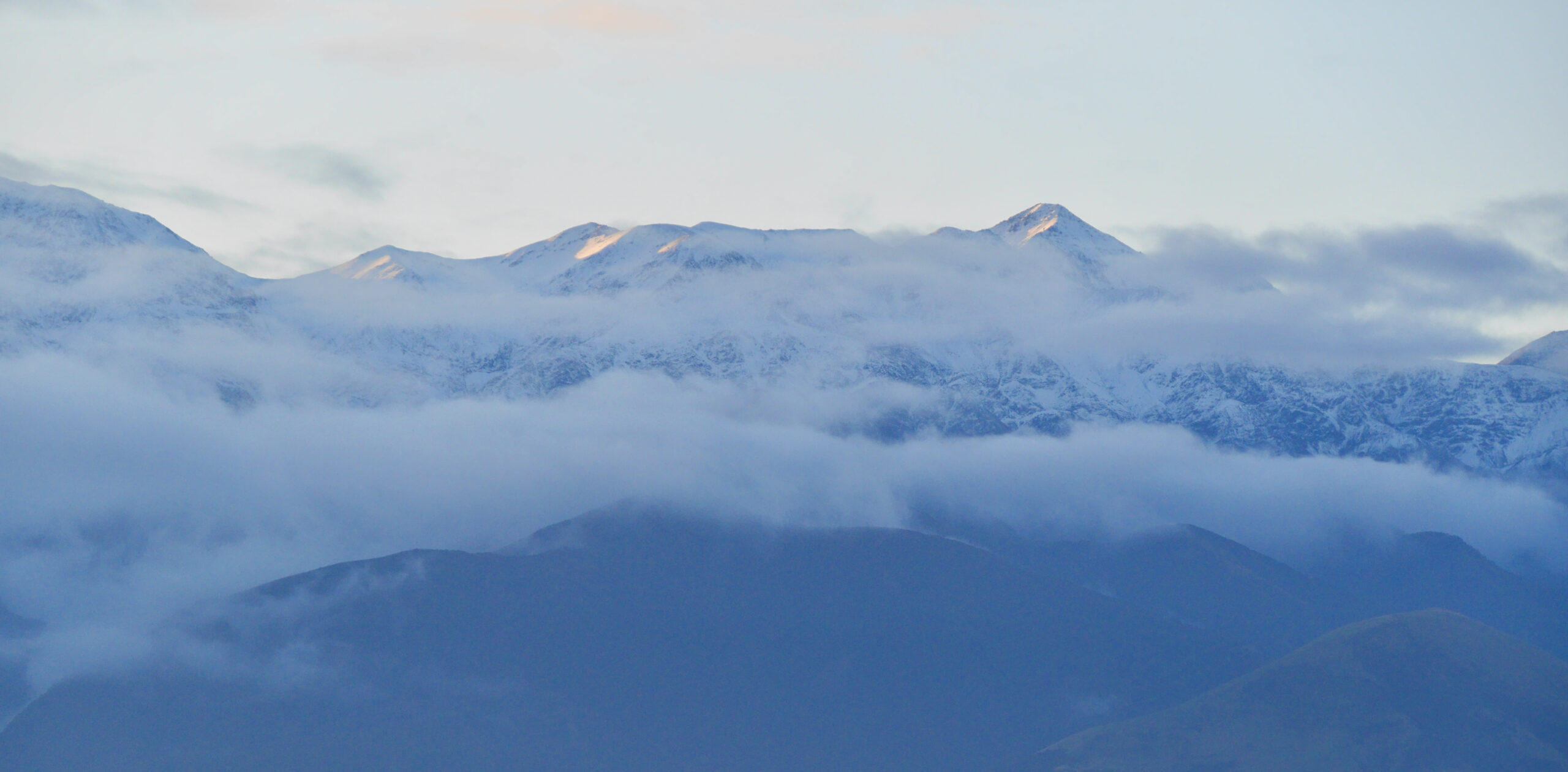
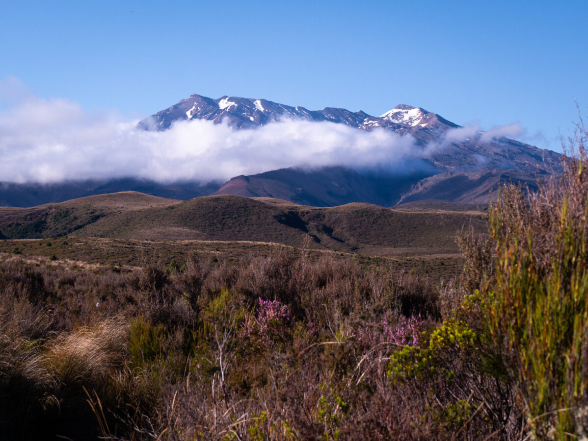
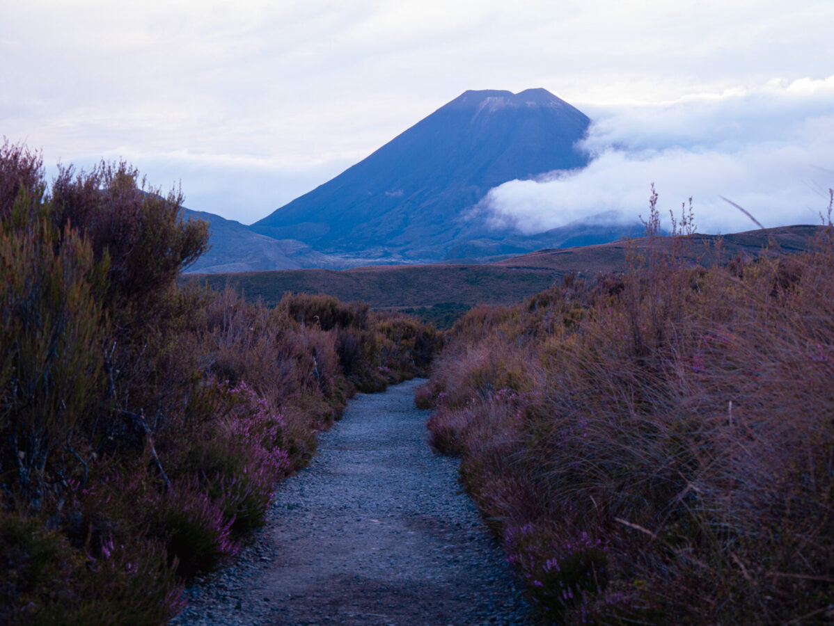
Behind me, the snow-covered volcano Mount Ruapehu stood impressively in the skyline, shrinking a little more with every step I took forward. My view in front was of Mount Nguaruhoe towering over the bushy landscape. This volcano, though it looked so far away, would be a central feature and landmark as I circled my way around it for the first several hours on the track.
I made it to Mangatepopo Hut around 9:45, where I took a break to stretch, drink some water and have a snack.
Shortly after leaving the hut, the trail wound its way into an old lava field. With huge chunks of volcanic rock spread out all over the valley, there were almost no plants except for some tussock grasses.
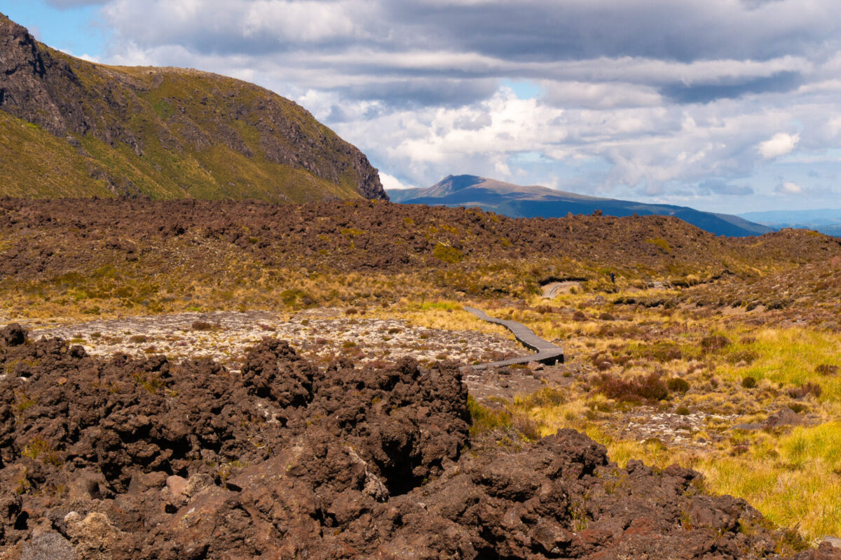
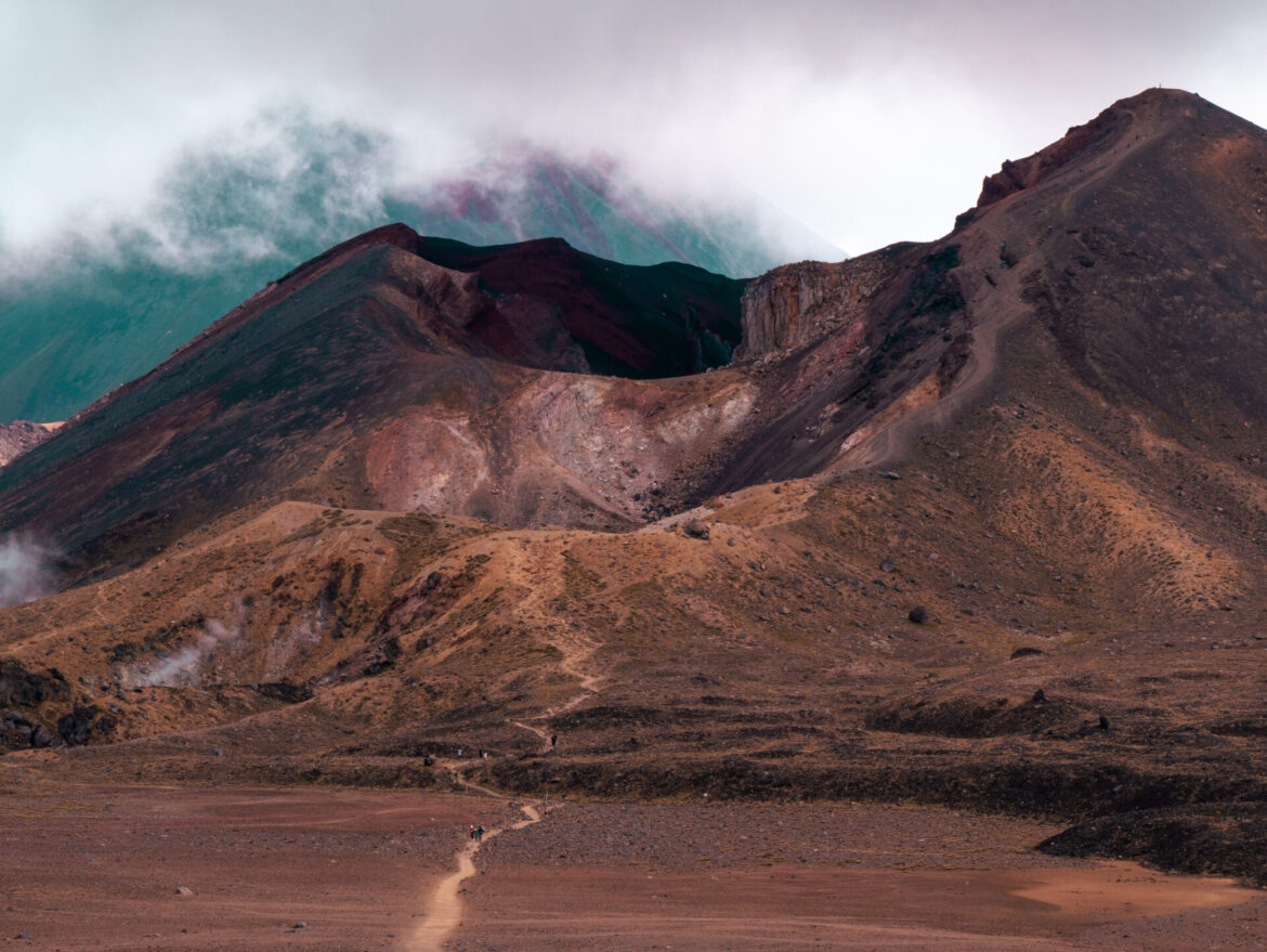
After hiking through the lava field for some time, it started to get real: I could see some staircases leading the trail upward. This is where the ascent to the highest point, the Red Crater, begins.
Once I began climbing, it got really steep and a lot of the trail was very rocky and uneven. Since there are no trees here, I was completely exposed and the hot, sunny weather made this part of the track even more challenging. I had to remove some layers, put on sunscreen and I drank a ton of water during this section.
Aside from the steepness, the uneven terrain, and the high temperature, hands down the worst part about climbing up to the Red Crater was all of the false summits! I counted about 4 of them, and each was just as disappointing as the next! This is something to keep in mind when hiking this track – don’t be fooled by flat terrain or what seems like the top! Just don’t get your hopes up. Even when it looks like you’re at the top, if you don’t see the Red Crater, it’s not the top.
After lotssss of teasing and some freaking epic views from all these false summits, I hiked the final ascent, which of course is the hardest and steepest of all, before reaching the highest point on the track adjacent to the famed Red Crater around 1 pm.
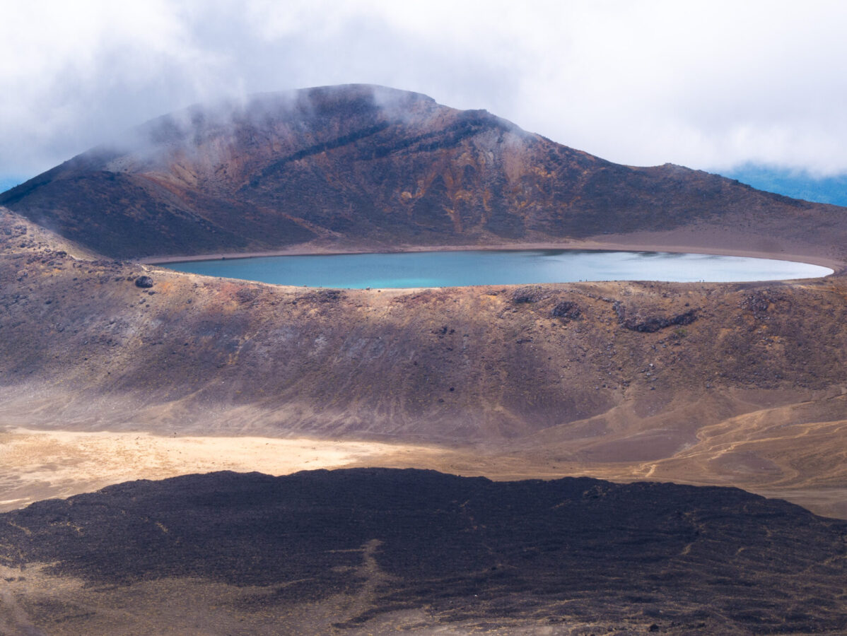
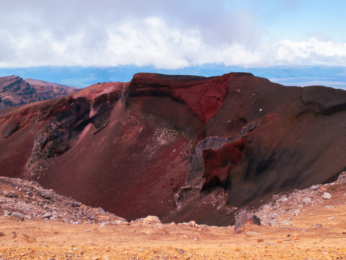
Once I could see the Red Crater, I knew I was basically there. I stopped for a few minutes to look inside the crater and bask in its unbelievability before continuing up to the top of the sandy slope, which marked the highest point on the Northern Circuit. Here, all of the views before were put to absolute shame by the breathtaking sights from all around this point. Behind me, I could still see Mount Nguaruhoe and the high valley which flanked it. Next to me was the crater, showcasing a past eruption in various colors of pink, brown, and crimson. And before me stood the Emerald and Blue Lakes surrounded by mountain peaks all around and some geothermal steam vents adding to the volcanic mystique.
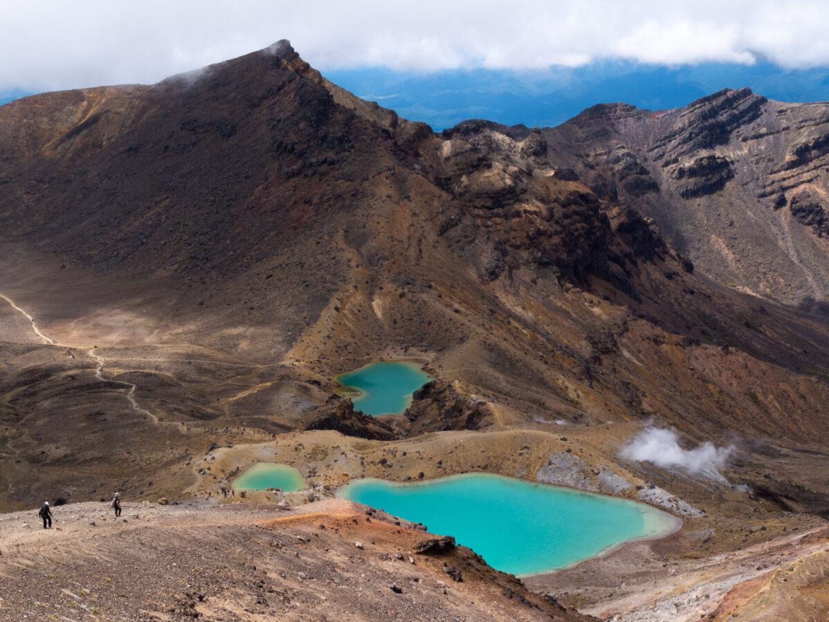
Hiking down to the Emerald Lakes, the slope was steep and sandy, like a massive sand dune, and my feet sank into the ground with every step. Rather than struggling to maintain my footsteps, I picked up my speed so I could hop along down the slope without worrying about keeping my feet stable. This was quite fun and worked well as I passed by some of the other hikers struggling to make it down! If you’ve ever ran down a sand dune, you might know what I mean. The sandy nature and steepness of this side of the Red Crater is another reason why I recommend doing this hike clockwise. (On another volcano hike in Guatemala, I had the displeasure of hiking up multiple steep, sandy slopes at high elevation and it was probably the hardest overnight hike I’ve ever done. So I can’t recommend hiking up something like this with a huge backpack while your foot sinks with every step when there is a better option.)
I took a long break down by the Emerald Lakes to rest and have lunch. I then began my trek down to the Oturere Hut, but first I took a quick side trip to Blue Lake (about 20 minutes return). The rest of the hike down to my campsite was through steep, rough, rocky sections of a lava field with massive volcanic rocks scattered around the trail.
The hut itself was also part of the lower version of this field and is near a waterfall. I arrived there around 4:30 pm.
Day 2: Oturere Campsite to end of the Northern Circuit at Whakapapa Village (23.5 kms, 8.5 hours)

On day 2, I woke up to heavy rain and unfortunately had to pack up a wet tent. I left Oturere campsite around 7:15 am, and for the first hour of my continued hike down through a valley of volcanic rocks, there was a lovely rainbow arching over the terrain. For the rest of the day, while the rain was never quite a downfall, I did spend most of the day hiking through light rain and somewhat chilly temperatures.
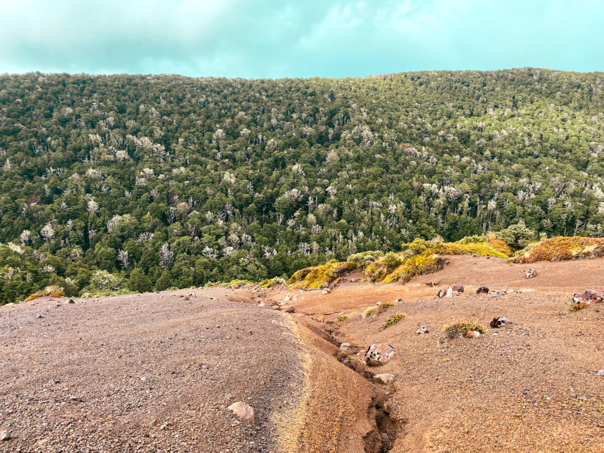
After a couple hours, I came to a forest of beech trees, which the trail hiked down into and then up over. After so much time looking at rocks and grass, this was a nice break from the otherwise volcanic remnants found on most of the trail. Once over the ridge and out of the forest, I was greeted by another rainbow. A little further after and I came to the Waihohonu Hut, where I took a break to stretch and have some snacks.
Just after the Waihohonu Hut lies the original Waihohonu Hut, which still stands and can be visited by hikers but is no longer used to host overnight hikers on the track. There is also Ohinepango Springs nearby, though I did not visit either since it was raining and my hike was already quite long.
A few hours after Waihohonu, I reached the Tama Lakes junction where there is another option to go on a side trip to Lower and Upper Tama Lakes (20 min and 1 hour and 30 min return, respectively). These lakes are former craters that have now filled with water and volcanic debris. Again, since I already had two long days in a row I decided to skip this side trip.
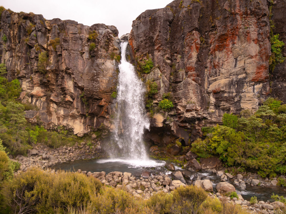
One side trip I did take, however, was the short hike down to Taranaki Falls near the end of my hike on day 2. You have the option to stand both on top of the waterfall as well as go down and see it from the other side where the waterfall creates a pool. It was so beautiful!
Once I left the falls I knew my hike was almost at the end. The terrain looked similar to the track in the morning on the first day, with the same bushy vegetation. Again I could see Mount Ruapehu in the distance. I continued to the end of the trail and then back into Whakapapa Village, which I reached around 4 pm.
Have fun & thanks for reading!
Have an amazing time on the Tongariro Northern Circuit! If you found this post helpful, please share with your hiker friends and let me know in the comments how your trip went. For further reading on other Great Walks in New Zealand, I’ve written up separate posts for the Routeburn Track, the Kepler Track, the Rakiura Track, and the Abel Tasman Track, so be sure to check those out!
Leave a Reply